IDENTITY CRISIS
THESIS

Communities are defined as a unified body of individuals sharing common interests, values, and/or beliefs. Often we speak of community as a united population, which bonds people together. However, Structuralist studies of Claude Levi-Strauss and Edmund Leach, in conjunction with the arguments of Richard Sennett, reveal communities are founded upon ideals of homogeneity and identity, through the generation of boundaries. The cultural construct of boundaries suppresses the complexity of the world around us, to rationalize and organize a more understandable one. Through the manipulation of architecture, boundaries may be reinforced to support a single interpretation or division of the urban context. However, this exploration seeks a different perception of contextualism, taking into account the complex variety of continuities and discontinuities apparent within our surrounding cities. Ultimately, this research and exploration attempts to generate an identity crisis, through the amplification of ambiguous space, which exists in the reality of urban form.
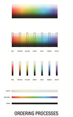
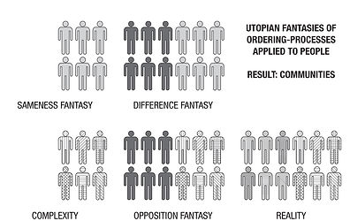

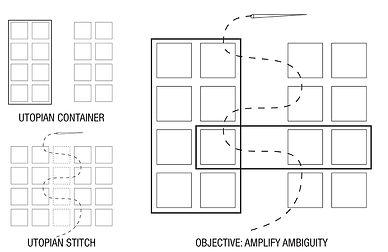
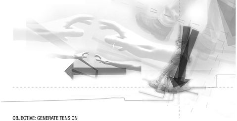
FROM THEORY TO OBJECTIVE: Structuralist theories revolve around the idea that human-nature cuts-up, arranges, and groups stimuli to dilute the complex world into understandable chunks. However, as seen in the color spectrum, ordering processes may compose multiple interpretations of organization. But, a single interpretation is never accurate in expressing the true complexity of the world. Within groups there is always some degree of difference, and between opposing groups there is always some degree of similarity. Interpretations reflect fantasies of pure sameness, difference, and opposition, rather than complex reality. Constructs ignore certain stimuli, generating spatial gaps between groups and supporting the logic of the interpretation. The space-between serves as a boundary, but it may be interpreted in many ways; a uniter, divider, or something completely other. Boundaries and ordering interpretations are cultural-constructs. Utopian forms either attempt to reinforce a boundary or completely eliminate it, but the objective is allow for the ambiguity between interpretations. Tension is achieved through continuities and discontinuities; close, but never quite complete, stable, or balanced.
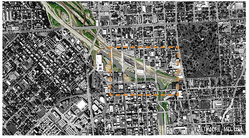
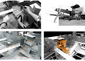
FROM BRAKETED-VISION TO DIAGRAM: Baltimore consists of your typical city grid, however as it meets the Jones Falls Valley, the grid ignorantly bridges across without change in elevation or attention to the landform’s existence. The intense spatial force of the valley is hidden from view, while preferencing the forces of the grid. The powerful space is revealed as you trespass into the world "under" the city. Understanding spatial forces requires tapping-into the our inherent bracketed-vision; the distorted perspective of the human eye. Constructing an experiential physical-model requires the user’s head to occupy the model, building to the distortion of the eye to represent the site. To experience the spatial forces of the site or an intervention, any person may insert their head into multiple locations in/around the model. The design and diagram of form is piloted from within the model, delivering immediate feedback to the designer in terms of spatial impact as experienced by a person in the world. The spatial information and data is precise, however the process of construction is loose, iterative, and mistake-driven to properly tune-in the space. Attempting to achieve the diagram’s objective, the form slips, reaches, pulls-back, and struggles to achieve certainty or stability.


PROPOSED DESIGN: The proposed design presents the architecture conventionally through four levels of elevation; +55', +35', +20', and +10'. The purpose of this arrangement is to show the varying levels carried through the topography in relation to the surrounding context. At each of these levels and in-between, the design suggests multiple interpretations of continuities and discontinuities in three-dimensions. Responding directly to the conditions and context of the site, the design is best presented in the moments of experiencing architecture within the surrounding context.
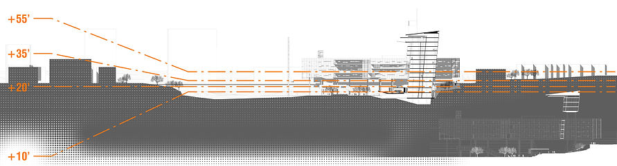


+55' ELEVATION: At the highest elevation, the structure maintains the continuity of built form which reaches across the valley. Although the existing condition of the valley creates a void in the building context, the intervention continues a perception of the city continues without disturbance. Essentially, north of the valley along Calvert Street, the intervention seems to be simply an urban infill project. However, walking further south as the topography begins to slope, a more complex situation is revealed.


+35' ELEVATION: When adjacent to the intervention, +35' occurs at street grade and continues along the bridges spanning the valley. At this moment one aspect of the structure is raised on piloti and it is understood that what seemed to be simple urban infill is actually floating overhead. Additionally, this arm, which seemed to be spanning completely across the valley and bridging the urban gap is actually falling short but more than half the valley. Located at the edge of built form along the north side, the second structure seems to be slipping into the valley, but leaning back to maintain its footing. As the building struggles to maintain a certain identity, the lower worlds of the city are beginning to become apparent.


+20' ELEVATION: This level of elevation is not quite the bottom of the valley, but is underneath the bridges. Units are also located at this level, providing a unique perspective in-between the city and valley worlds. Most of the tension of the architecture occurs at this point, as the building fights to establish an identity with the multiple communities transitioning at this elevation

+10' ELEVATION: The lowest portion of the design develops a linear park, which parallels the railroad and the valley spatial forces. The park continues many blocks beyond the building site to reinforce the strong continuity of the valley. Units, underground parking, and a restaurant occupy this region, providing more suburban characteristics of space within the city.

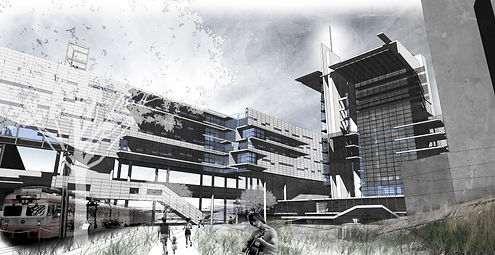
AFTERWORD: The final proposal is realized in a relatively radical, architectural form. It is important to note that the underlying research, process, and proposal is not an argument about style. Looking-back upon what was learned, the proposal may be achieved through a more moderate style of architecture, without losing its provocative challenge to the understanding of our boundaries. The primary concern of the exploration was to develop an architecture that formally responded to the urban context. With further development, the program of the 80 building would be taken into much more consideration and the role of the unit further developed.
However, the proposal raises several questions remaining unanswered and unexplored. What does this research mean for the future of architecture, especially along the invasive boundaries of freeways and infrastructure that carve through our cities? Designers are constantly engaging in the conversation of how to resolve the freeway situation through cities, often turning buildings' backs upon these routes. But the freeways, man-made topography, and infrastructure has all become part of the essential context to the complex and living city. We must somehow coexist with these elements in order to progress. The question is how will designers realize potential in these complex sites and heterotopias?